Directions to Jeff & Nancy's House
From or Via Boston
Via the Mass Pike
From the Northern Suburbs Inside Rte. 128
From Logan Airport
These are the detailed directions. If this is too much detail, try the short directions instead.
Notes:
Please note that we have two cats. If you are allergic to cats, don't
forget to bring your antihistimines.
The maps on this page were produced by MapQuest and edited with xpaint.
From Boston/Cambridge or other places inside
Rte. 128:
Summary: Mass Pike through Ted Williams Tunnel to Rte. 1A North; or
Callahan Tunnel/Rte. 1A North; or Rte.1/Tobin Bridge to Rte. 16 East. Take any
of these to Bell's Circle.
Details:
Estimated travel time from Downtown Boston is 25 minutes in light traffic
and 40-50 minutes in rush hour traffic. If you're driving any time near rush
hour, it's usually worth checking the traffic reports. You can get traffic
reports from SmarTraveler ((617) 374-1234, or *1 on some cell phones), or from
some of the local radio stations. WBZ radio (1030 AM) provides traffic reports
every ten minutes, "on the 3s".
Via the Mass Pike (I-90) and the Ted Williams Tunnel:
If you're going this way during (or close to) rush hour, check the Mass
Pike traffic report.
- Follow the Mass Pike (I-90) East until it ends.
- When the Mass Pike ends, it will dump you on Rte. 1A
North. Continue on Route 1A North to Bell's Circle.
- You'll actually be staying on 1A through Bell's Circle, but at this
point, you should jump to the directions below, labeled "From Bell's Circle."
Via Rte. 1A and the Callahan Tunnel:
If you're going this way during (or close to) rush hour, check the Sumner
& Callahan Tunnel traffic report.
- Get onto Route 1A North. From the Central
Artery/Fitzgerald Expressway/I-93, this is Exit 24B (Callahan
Tunnel/Logan Airport).
- Go through the Callahan Tunnel and and continue up Route 1A North to
Bell's Circle.
- You'll actually be staying on 1A through Bell's Circle, but at this
point, you should jump to the directions below, labeled "From Bell's Circle."
Via Rte. 1 and the Tobin Bridge
If you're going this way during (or close to) rush hour, check the Rte. 1
traffic report.
- Get onto the Tobin Bridge/Rte. 1 North. From the
Central Artery/Fitzgerald Expressway/I-93 Northbound, this is Exit
27 (left exit). During rush hour, it's often faster from Cambridge to
avoid the artery and get on the Tobin Bridge via the Prison Point
(Gilmore) Bridge.
- About a mile after the Tobin bridge ends, exit onto Rte. 16
East, towards Revere Beach/Lynn.
- Follow Rte. 16 until it ends at Bell's
Circle.
- From there, follow the directions below labeled "From Bell's Circle."
Via Rte. 16 or Rte. 60 (From the Western Suburbs inside Rte. 128):
Estimated travel time from Alewife or from Arlington Center is 30 minutes
in light traffic and 45 minutes in rush hour traffic.
- Take route 16 East or Rte. 60
East until it ends at Bell's Circle.
- From there, follow the directions below labeled "From Bell's Circle."
Estimated travel time from Logan Airport is 20-25 minutes.
- Get onto Route 1A North toward Lynn and Revere. (This
exit is also labeled as an alternate route to the tunnel, although you
will be heading away from the tunnel.)
- Follow Rte. 1A North to Bell's Circle.
- You'll actually be staying on 1A through Bell's Circle, but at this
point, you should jump to the directions below, labeled "From Bell's Circle."
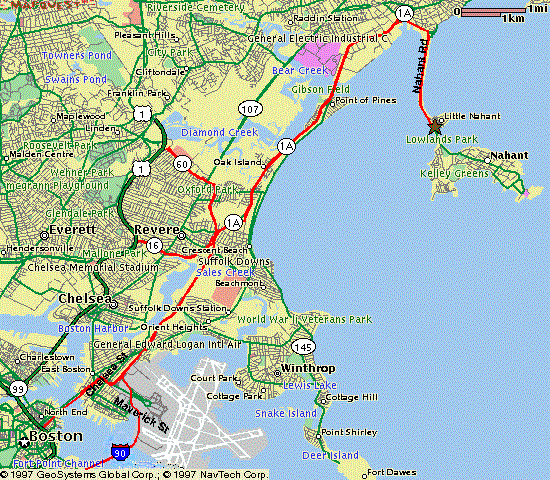
Summary: Find Rte. 1A North to Revere Beach/Lynn and get
on it. Stay on parkway when 1A turns off. At rotary, take causeway to Nahant
(1st exit). At end of causeway, take second left. Second house on the left.
Estimated travel time from Bell's Circle is 10-15 minutes.
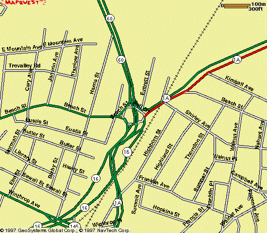
Bell's Circle is a confusing intersection at which Route 1A and the
endpoints of Rte. 16, and Rte. 60 all come together. The intersection is a
rotary with a divided highway going through the middle and traffic lights
everywhere. In the middle of the rotary, the divided highway changes from
Rte. 60 (which ends at that point) to Rte. 1A.
Details:
- No matter which road you're coming in from, go around the outside of the
rotary (do not go through the middle) and exit onto
Rte. 1A North towards Lynn. Note your odometer reading
or zero your trip odometer here.
If you're coming via Rte. 60, there are no signs for Rte. 1A Northbound.
The entrance to the rotary is just after a 3-story-high rock wall.
You'll be going about 3/4 of the way around the rotary.
- Follow Rte. 1A North for a total of 4.8 miles from Bell's Circle
(staying on 1A through the Wonderland rotary) onto the Lynnway in Lynn.
Here are some landmarks, with mileages from Bell's Circle:
Miles
From
Prev. |
Total
Miles |
Description of Intersection or Landmark |
| 0.0 mi. |
0.0 mi. |
Bell's Circle. Pseudo-rotary where Rtes. 1A, 16, and 60 meet.
Exit the intersection onto Rte. 1A North
towards Lynn.
|
| 0.5 mi. |
0.5 mi. |
Wonderland rotary. Go 3/4 of the way around, staying on 1A
North, which is now North Shore Road.
|
| 0.1 mi. |
0.6 mi. |
Wonderland Blue Line T Station on your right. |
| 2.6 mi. |
3.2 mi. |
Steel deck drawbridge. As you cross it, you can see Nahant off
to your right. Once you're across the bridge, you're on the
Lynnway in Lynn. |
| 1.6 mi. |
4.8 mi. |
Go straight on the Carroll Parkway (1A turns
off) at the 7th traffic light after the drawbridge. |
- When 1A turns off, continue straight on the
Carroll Parkway (stay in the right lanes), following
the sign for Nahant/Swampscott.
- 0.5 mile after 1A turned off, you will come to a rotary. Take the
first (right) turn out of the rotary, about 1/4 of the
way around, onto the Nahant causeway. You're now on Nahant
Rd. in Nahant.
- Travel the length of the causeway (about 1.4 miles). If it has recently
rained heavily and it is near the time of high tide,
stay in the left lane.
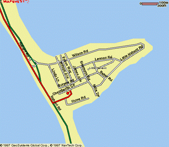
- After the causeway ends, go 0.2 mile and take the second
left onto Little Nahant Road. This turn is
hard to see until you're right there, but there's a stone wall on your
left just before the turn. If you come to a boarded up Coast Guard
station on your left, you went too far.
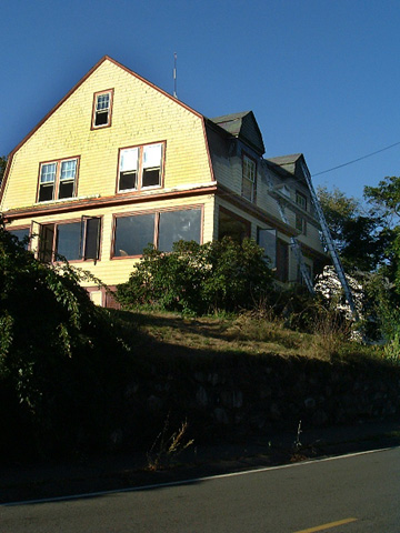
- Our house is 8 Little Nahant Road. It's the second
house on the left, at the first curve in the road. The house is a
yellow gambrel-roofed Dutch colonial with red and brown trim. The house
number is on the lamp post.
The best places to park are in the driveway, in the spaces behind the
garage (which are accessible from Chamberlin Circle), or on etiher side
of Chamberlin Circle. If Chamberlin Circle is parked up, ask us for
other options. (Sometimes some of our neighbors let us use parts of
their driveways.)
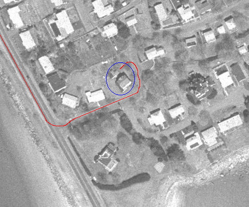
Here is a picture of the house, as you approach it on Little Nahant Road:
Telephone
Our telephone number is (781) 592-5802.
Other directions to Jeff & Nancy's house / jcb's homepage / send email
Last modified: Sat Feb 7 20:54:38 2004
by jcb@mit.edu