
PART-TASK SIMULATION STUDY OF
CANDIDATE TERRAIN ALERTING DISPLAYS
James K. Kuchar
R. John Hansman, Jr.
Aeronautical Systems Laboratory
Department of Aeronautics & Astronautics
Massachusetts Institute of Technology
Cambridge, Massachusetts USA
June 30, 1993
ASL-93-6
Abstract
Three candidate terrain alerting displays were evaluated in a part-task simulation study. A plan view format depicted terrain using contours on the Electronic Horizontal Situation Indicator. The second display showed terrain along the aircraft’s track in profile. A three-dimensional perspective view of the terrain on the artificial horizon was the third display format used. Pilots from major airlines flew the simulator through several hazard incidents, in which they first made an estimate of the severity of the hazard by pressing one of four autopilot disconnect buttons and then flew an escape maneuver using a sidestick.
No display format was found to be entirely effective in conveying the true level of hazard posed to the aircraft when descending into flat terrain. The profile and perspective displays were found to overemphasize the hazard when the aircraft was turning safely in front of a mountain range. Lateral maneuvers were initiated in the majority of cases (80%) when using the plan view, 30% when using the perspective view, and 5% of the time when using the profile view. When in a turn when a hazard appeared, pilots went to a wings-level pull-up maneuver significantly less often when using the plan view display as opposed to the profile or perspective views. Subject preferences were for the plan or perspective view displays, with the lack of lateral information on the profile display cited as the principle reason for that display’s low ratings.
1. Introduction
Ground Proximity Warning Systems (GPWS) are provided on air transport aircraft to warn flight crews of unintended flight toward terrain, and have been successful in reducing the number of Controlled Flight Into Terrain Accidents over the last two decades. These systems use a look-down radar altimeter to measure altitude above ground and terrain closure rate but are unable to sense terrain ahead of the aircraft. This lack of information about the three-dimensional environment around the aircraft is a drawback in the effectiveness of GPWS. For example, if an aircraft were to fly over a hill with steep slopes, GPWS would extrapolate the rapid change in terrain altitude and might determine that a hazard existed to the aircraft, when in fact there was no danger (Fig. 1A). Such a situation is termed a ‘nuisance alert’ because the GPWS extrapolated its limited knowledge of the terrain into a hazard, yet no action was actually required by the crew. The current system may also not provide enough warning time to the crew when the aircraft flies toward very steep terrain (Fig. 1B).
In addition to these performance drawbacks, current GPWS only provides the flight crew with an aural alert and a single light on the cockpit panel, often leaving the flight crew without an understanding of the underlying cause for the alert and with only a rough idea of the urgency required. In a survey distributed by the Air Line Pilots’ Association, pilots indicated that they took immediate action in response to a "whoop whoop, pull up" alert only 27% of the time. In the remainder of the cases, the flight crews investigated the matter further before taking action or determining that it was a nuisance alarm. It is believed that this behavior stems from previously experienced nuisance alerts, poor training in terrain avoidance procedures, and lack of an intuitive display of the true hazard situation. The end result is a system which may not provide enough time for the pilot to verify the alert and then respond as required.

A B
Figure 1
Schematic of nuisance alert (A)
and inadequate response time (B) situations
An advanced GPWS which is able to incorporate information about the terrain ahead and to the sides of the aircraft may greatly increase the effectiveness of terrain alerting while reducing the rate of nuisance alerts. Terrain information may be obtained from an on-board database or using a look-ahead sensor. Still, like any warning system that trades response time for the acceptable severity of the hazard, such a system will have occasional nuisance alerts. An effective advanced GPWS design will need to depict complex hazard situations in an intuitive manner to the crew.
It is believed that an electronic display using terrain information from an on-board database or from a look-ahead sensor could provide the flight crew with the information they need to quickly determine the severity of the hazard situation. Three candidate terrain alerting displays (plan , profile , and three-dimensional perspective view) are under consideration for possible use in an advanced GPWS system. A study was performed at MIT to investigate the potential advantages and disadvantages of these terrain alerting display formats. Pilots of ‘glass cockpit’ aircraft flew a part-task simulator through a number of terrain hazard incidents, and their estimates of the level of hazard as well as their escape maneuver trajectories were recorded.
2. Facilities and Display Formats
The study was conducted using the MIT ASL part-task simulator, which depicted a Primary Flight Display (PFD), Electronic Horizontal Situation Indicator (EHSI), and hazardous terrain in one of the three display formats, as shown in Figure 2.1. Dynamics were based on 737-100 parameters, with sidestick control laws based on the A320. Mode Control Panel (MCP) status was also displayed and the conventional GPWS was disabled. The MCP was used by the subject to set aircraft heading and altitude. When performing a terrain escape maneuver, the subject used a sidestick, which commanded pitch rate (load factor) and roll rate. One of three buttons on the stick was used to disconnect the autopilot and enable the sidestick. Each button was used by the subject to indicate a different estimate of severity of the terrain hazard. A fourth button could be pressed to indicate that the terrain did not pose any hazard to the aircraft. Relevant flight parameters (pitch, load factor, velocity, etc.) were recorded by the simulator during each scenario.
Terrain data resolution on the displays was 12 arc seconds (approximately 1,200’) horizontally and 100’ or 200’ vertically. The terrain data was obtained from a CD-ROM disk which covered the Rocky Mountain region of the U.S. No smoothing of the terrain data was performed; terrain appeared as blocks on the different displays. The terrain alerting display was initially blank, and terrain alerts, when called for in the scenario, appeared suddenly on the display along with an aural warning of "terrain!". Three colors were used to identify the relative altitude of the terrain: green was used for terrain which was more than 1,000’ below the aircraft, amber represented terrain less than 1,000’ below the aircraft, and red was used for terrain above the aircraft. The aircraft’s horizontal proximity to terrain and descent rate did not affect the color coding of the terrain; instantaneous vertical separation was the only factor that determined terrain color. While this shading scheme may not be feasible on an actual aircraft, it was used here to provide an unambiguous depiction of relative terrain altitude to the pilot.

Figure 2.1
Simulator Display Layout (schematic)
Three terrain displays were investigated: plan view, profile view, and perspective view. The plan view terrain alerting display (Figure 2.2) depicted hazardous terrain on the EHSI, which was set to a 10 NM scale. Terrain colors were updated every 200’ as the aircraft climbed or descended. A lateral trend vector was provided on the EHSI which depicted the projected ground track 30 seconds into the future. The position at which the aircraft would reach MCP commanded altitudes was shown on the EHSI as a green arc as is done on conventional navigation displays.
The profile view terrain alerting display (Figure 2.3) depicted hazardous terrain in a separate window below the EHSI. The ownship symbol was on the left side of the display, and an altitude tape was on the right side of the display. Hazardous terrain within 10 NM along the aircraft’s track and 2,000’ vertically was shown, at altitudes rounded to the next higher 100’. Green, amber, and red were used to denote terrain in the same manner as on the EHSI. Projected vertical flight path was shown using a dashed magenta line, and the MCP commanded altitude was shown using a horizontal green line.
Perspective terrain alerts appeared on the Electronic Attitude Director Indicator (EADI), as shown in Figure 2.4. A velocity vector was added to the EADI in order to aid the subject in estimating the aircraft’s flight path. The velocity vector symbol was based on that used on civil Head Up Displays, and its use was fully explained to the subject. Hazardous terrain within 10 NM and 20 degrees of the aircraft’s heading was shown in three-dimensional perspective as colored blocks. The same green-amber-red color scheme as mentioned earlier was used to depict the terrain. To speed the display update rate, terrain within 5 NM was shown at 1,200’ resolution (12 arc seconds), while terrain more than 5 NM from the aircraft was shown at 2,400’ resolution (24 arc seconds). The terrain blocks’ altitudes were rounded to the next higher 100’ as was done on the profile view display.

Figure 2.2
Plan View Display
(actual display size: 7" x 6")

Figure 2.3
Profile View Display
(actual display size: 2.5" x 6")

Figure 2.4
Perspective View Display
(actual size of artificial horizon: 3" x 3")
3. Procedure
3.1 General Procedure
Subjects flew the simulator through 36 short scenarios while viewing one of the three alerting display formats. Each scenario began with the aircraft in straight and level flight, and in some scenarios was followed by an Air Traffic Control (ATC) clearance to change to a different altitude or heading. The subject complied with the clearance using the MCP to control the aircraft. By controlling the aircraft’s maneuvers, the subjects were aware of the aircraft’s state when the terrain alert occurred. Shortly after executing the ATC request, an aural alert, "terrain!", was sounded simultaneously with the graphical indication of ground proximity that appeared on the terrain display being studied.
Table 3.1
Terrain Hazard Categories
|
Hazard Level |
Sidestick Button Number |
Qualitative Description |
Actual Trajectory Required to Avoid |
|
None |
1 |
Terrain poses no threat. Aircraft may continue on autopilot and will remain clear of terrain. |
terrain is not within 1000’ vertically |
|
Slight |
2 |
Terrain poses a slight threat. A small flight path correction is required, but immediate action is not necessary. |
< 1.05g, 2000 fpm climb |
|
Moderate |
3 |
Terrain poses a moderate threat. A moderate flight path correction is required with a minimum of delay. |
1.05g, 2000 fpm climb to 1.1g, 3000 fpm climb |
|
Severe |
4 |
Terrain poses a severe threat. An immediate, severe escape maneuver is required. |
> 1.1g, 3000 fpm climb |
When the alert occurred, the subject pressed one of four buttons on the sidestick, each corresponding to a different perceived level of hazard posed by the terrain, as shown in Table 3.1. Terrain hazard levels were separated on the basis on the minimum required maneuver to clear the terrain, in terms of load factor during the pull-up and the final climb rate needed. Three buttons (for slight, moderate, and severe hazards) disconnected the autopilot, automatically advanced the aircraft’s throttles to maximum thrust, and allowed the subject to fly an escape maneuver using the sidestick. Pressing the button corresponding to a non-hazardous category did not disconnect the autopilot or enable the sidestick; the subject could, though, later press one of the other buttons to allow for manual control.
3.2 Specific Procedure
Typical sessions with subjects proceeded as follows. The subjects were introduced to the simulator and its displays and controls. The Mode Control Panel was demonstrated, and the subjects flew the simulator using the sidestick to become familiar with its behavior. The four terrain hazard levels were qualitatively explained to the subjects as described in Table 3.1. The numerical criteria defining the differences between hazard levels were not explained.
A short training period then followed which allowed the subjects to practice pressing the buttons on the sidestick corresponding to the different hazard levels. An abstract graph of hazard level was displayed on the screen, and the subject pressed one of the sidestick buttons. Correct decisions were verified by lighting a box in green; incorrect decisions lit the box in red and sounded a beep. This procedure was repeated over 24 runs.
The subjects were instructed to fly the simulator with the same standards of safety as they would on an actual flight. They were also told that not all situations would be truly hazardous, and that they would be scored on how well their estimate of the level of hazard compared to the true hazard level. It was also reiterated that the sidestick would only become active once one of the three hazard buttons was pressed.
When the subjects felt comfortable with the operation of the sidestick and with the use of the sidestick buttons to indicate the level of hazard, the first terrain display format (as dictated by the test matrix) was shown and explained. Four training scenarios were run with this display format, providing the subjects with an opportunity to ask questions and become accustomed to the display’s operation.
Twelve data collection scenarios were then run using the first display format. In each scenario, the aircraft began in straight and level flight, with no terrain information on the displays. As dictated by the test matrix, in some scenarios an Air Traffic Control (ATC) clearance to turn or descend was given shortly after flight began. The ATC clearances were printed on the computer screen with a message such as "Turn Right Heading 060". At preset times, headings, or altitudes a terrain alert popped up on the display along with the aural alert "terrain!". In each particular scenario, terrain appeared in the same position relative to the aircraft regardless of the display used and regardless of the time it took the subject to perform the maneuver stipulated by ATC. When the hazard appeared on screen, the subject indicated the hazard level by pressing one of the four buttons on the stick. If appropriate, the subject then flew an escape maneuver. The scenario ended when the aircraft had cleared the terrain and reached a steady climb rate and returned to wings-level flight.
After running the 12 scenarios with the first display format, the subject was trained on the next display format in the same manner as before. Twelve data collection scenarios were run with the second format, followed by a similar procedure for the final display format. At the conclusion of the study, the subject was interviewed using the questionnaire shown in Appendix A.
3.3 Test Matrix
Independent Variables
• Alerting display format
Terrain information was shown using the plan, profile, or perspective view displays described in Section 2. The order in which these display formats were presented was counterbalanced across the subjects. Each subject used a particular display format through 12 scenarios before changing to the next format.
• Level of hazard
Four levels of hazard were used, classified according to the vertical maneuver required to avoid the terrain (Table 3.1).
• Maneuver prior to Alert
Before the terrain alert occurred, the aircraft was cleared to descend or turn, or was not given any clearance. When descents were given, the terrain alert occurred after the aircraft had reached a preset altitude with a steady descent rate (2,000 fpm). When turns were given, the terrain alert occurred when the aircraft had reached a preset heading at a constant bank angle (20û). Terrain alerts appeared at preset times when no ATC clearance was issued.
The three types of ATC clearances at each of the four hazard levels resulted in 12 scenarios (Table 3.2). The same 12 scenarios were presented in a block-randomized order in each of the 3 alerting display formats. This allowed for a direct comparison between displays for identical hazard situations. Due to the large differences in the manner in which the terrain was depicted on each of the three display formats, no familiarity effects were expected. Table 3.3 shows an example test matrix for one subject. Scenario order was block-randomized, and display format order was counterbalanced across subjects.
Table 3.2
Scenario Hazard Rating Assignment
|
Scenario |
ATC Clearance |
True Hazard Level |
Scenario |
ATC Clearance |
True Hazard Level |
|
|
1 |
None |
None |
7 |
None |
Moderate |
|
|
2 |
Descend |
None |
8 |
Descend |
Moderate |
|
|
3 |
Turn |
None |
9 |
Turn |
Moderate |
|
|
4 |
None |
Slight |
10 |
None |
Severe |
|
|
5 |
Descend |
Slight |
11 |
Descend |
Severe |
|
|
6 |
Turn |
Slight |
12 |
Turn |
Severe |
Table 3.3
Example Scenario Order For One Subject
|
Scenario Order |
6,10,4,9,7,11, 12,3,8,2,1,5 |
5,7,4,9,8,3, 11,12,10,2,6,1 |
11,8,3,7,1,6, 10,2,4,12,9,5 |
|
Display Format |
Plan |
Profile |
Perspective |
The scenarios were designed in an attempt to highlight the advantages and disadvantages of each display format and provided varied types of hazards. For example, one scenario involved clearing the aircraft to descend into flat terrain. Other scenarios involved turning toward or away from a terrain hazard, or flying directly toward a ridge.
Dependent variables
• Objective performance during the escape maneuver. Aircraft pitch, normal acceleration, bank angle, and other relevant parameters were recorded.
• Subjective rating of hazard severity through the use of the autopilot disconnect buttons.
• Subjective comments and opinions on the display formats.
4. Results
Six subjects participated in the study, with an average age of 51 years and 16,300 hours of civil flight time. An average of 2,510 hours had been spent on Flight Management Computer equipped aircraft. Five subjects were captains; one was a first officer. One subject had retired in the previous year, while the others were active pilots.
4.1 Relation between true and subjective hazard levels
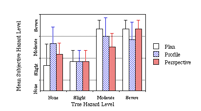
The mean hazard level indicated by the subjects for each scenario are shown in Figures 4.1 through 4.3. The subjective hazard ratings were quantified by assigning each button on the sidestick an integer value, ranging from 0 for the non-hazard button, to 3 for the severe hazard button. The mean of these button values over the six subjects was then plotted in Figures 4.1 to 4.3. Error bars in these figures represent one standard deviation of the distribution in button values. Figure 4.1 shows hazard level estimates for each display format for the scenarios which did not involve an ATC clearance (scenarios 1, 4, 7, and 10), in order from the non-hazard scenario to the severe hazard scenario. Figure 4.2 shows similar data for scenarios in which the aircraft was in a descent (scenarios 2, 5, 8, 11) when the terrain alert appeared, and Figure 4.3 has the data for scenarios in which the aircraft was turning (scenarios 3, 6, 9, 12) when the hazard appeared.
Care must be exercised when drawing conclusions from Figures 4.1 through 4.3. Each scenario was unique in that the layout of terrain and the aircraft’s proximity to the hazard was different from any other scenario. In addition, the criteria used to differentiate the hazard levels may not have been the same as that used by the pilot, nor was it necessarily a linear scale. For example, a pilot may have rated a scenario as more hazardous than it was (as rated by the criteria in Table 3.1) because of the presence of high terrain to the sides of the flight path; the criteria used to categorize the hazards did not take this type of information into account.
Still, the data in Figures 4.1 to 4.3 show a general trend where pilots tended to rate situations as more hazardous than they were according to the criteria of Table 3.1. Two scenarios stand as outliers, however: the severe hazard scenario in Figure 4.2 was rated as less severe than it probably should have been, and the non-hazard scenario in Figure 4.3 was generally rated as a slight or moderate hazard. These two cases will now be discussed in more detail.


The ‘Severe’ scenario in Figure 4.2 involved a situation where the aircraft was descending into a flat terrain field, and where the alert appeared when the aircraft was less than 250’ above the terrain. At the descent rates used (2,000 fpm), this provided approximately 7 seconds warning before impact. All three display formats evidently did not convey the true level of hazard, since the situation received a mean rating between slight and moderate. Part of the reason behind the low subjective ratings may be due to the fact that the terrain coloring scheme used in the study did not take descent rate into account; the terrain was colored in amber, not red, in this scenario, possibly leading pilots to underestimate the hazard. Still, it is evident that none of the displays provided a very compelling picture of the situation. In fact, the subjects impacted the terrain before arresting their descent 50% of the time when using the plan view format, and 50% of the time when using the perspective format. No subject impacted the terrain when using the profile view format, suggesting that the profile display at least provided a better indication that the aircraft was in an undesirable situation than the other displays.
The non-hazardous scenario in Figure 4.3 involved the aircraft turning ahead of a line of mountain peaks. There was no true hazard to the aircraft, since its flight path turned away before getting within several miles from the ridge. Such a fact was evidently not clear, especially when using the profile or perspective formats. In these formats there was not enough lateral information on the display to indicate that the aircraft would clear the terrain without any aid from the pilot. However, even when using the plan view format, where the trend vector showed the aircraft’s trajectory turning before reaching the ridge, four of the six pilots felt the situation was tenuous enough to warrant taking over with the sidestick.
Several of the differences in subjective hazard ratings across display formats are statistically significant using a paired t-test. In Figure 4.1, the ‘Slight’ and ‘Moderate’ scenarios had subjective ratings for the plan view significantly below and above the profile and perspective displays respectively (p < 0.05). In Figure 4.3, the profile view display ‘No Hazard’ scenario was rated as significantly more hazardous than the plan view display scenario (p < 0.05). In the Figure 4.3 ‘Moderate’ scenario, the perspective view display provided significantly lower hazard ratings than the plan and profile displays (p < 0.05).
4.2 Relation between load factor and hazard level
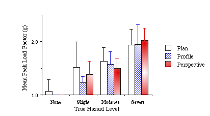
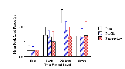
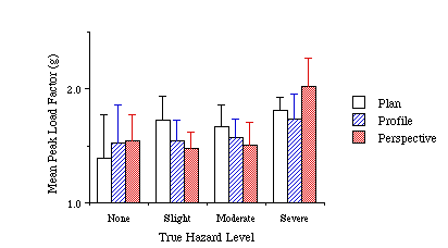
Figures 4.4 through 4.6 show the mean peak load factor experienced during the escape maneuver for all subjects. Load factor is defined as the acceleration along the aircraft’s negative-z body axis (pointing ‘up’, in g’s), and is a measure of the rate of change of the direction of the aircraft’s velocity vector. The peak value of load factor was the largest z-axis acceleration experienced during the scenario. Note that the data presented in Figures 4.4 to 4.6 show the peak load factors experienced during the escape maneuver, and do not account for the time period over which the maneuver was executed. The error bars on these graphs represent one standard deviation of the distribution of peak load factors for each subject. In general, Figures 4.4 through 4.6 show similar correlation between the true level of hazard and the load factor as was seen when comparing subjective and true hazard levels. The same two outlier situations can be seen in these data also, for the scenarios involving the turn away from a ridge and the scenario with the hazardous descent into flat terrain.
There were four cases in which the differences between displays in peak load factor were statistically significant using a paired t-test. The perspective view display had a significantly higher peak load factor than the profile view display in the ‘Slight’ scenario in Figure 4.4 (p < 0.05) and in the ‘Severe’ scenario in Figure 4.6 (p < 0.05). The plan view display had significantly higher peak load factors than the perspective view display in the ‘Moderate’ scenarios in Figures 4.4 (p < 0.05) and 4.5 (p < 0.01).
(Descent scenarios)
(Turn scenarios)
4.3 Climb rate and hazard level
Figures 4.7 through 4.9 show the mean peak climb rates experienced in the escape maneuvers used across the three display formats. In 7 of the 12 scenarios, the profile display exhibited the lowest peak vertical speeds of the three display formats. In no case did the profile view display elicit the highest climb rates of the three displays. In all but three scenarios, the subjects’ highest climb rates were found when using the perspective view display. In addition, in the scenarios where the profile display climb rate was significantly less than the other formats’ climb rates, the minimum height above ground was never significantly lower when using the profile display. In fact, in one scenario the minimum height above ground was significantly higher (p < 0.05) with the profile display than with the perspective display, even though the profile display had a significantly lower climb rate. The fact that lower climb rates were seen with the profile display does not indicate that the profile display was less effective in aiding the pilots to climb - rather, it may be that the profile view display, because it highlighted the vertical flight path, was more efficient in enabling the pilots to clear terrain without using excessive climb rates. Alternatively, the perspective view display may have exaggerated the amount of vertical separation that the pilot required to clear terrain, leading to higher climb rates when using this display.
Six scenarios had statistically significant differences in climb rates using a paired t-test. In the ‘Slight’ scenario in Figure 4.7, the perspective display had significantly higher climb rates than the plan or profile displays (p < 0.05). The plan view display had significantly lower climb rates than the perspective view display in the ‘Moderate’ scenario in Figure 4.7 (p < 0.05). Significantly lower climb rates were seen with the profile display as opposed to the plan or perspective display in the ‘Moderate’ and ‘Severe’ scenarios in Figure 4.8 and the ‘Slight’ scenario in Figure 4.9 (p < 0.05). In the ‘Severe’ scenario in Figure 4.9, the profile view had a significantly lower climb rate than the perspective display (p < 0.01).
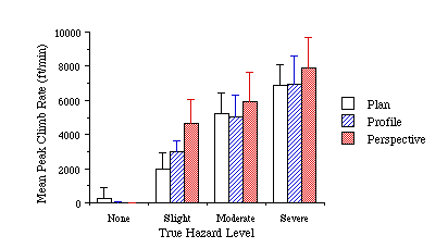
Figure 4.7
Mean Peak Vertical Speed
(straight and level scenarios)
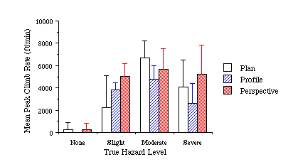
Figure 4.8
Mean Peak Vertical Speed
(descent scenarios)
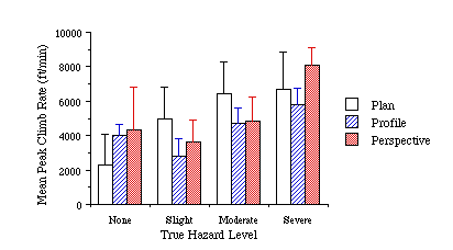
Figure 4.9
Mean Peak Vertical Speed
(turn scenarios)
4.4 Lateral maneuver initiation
Figure 4.10 shows the rate at which lateral maneuvers were initiated for the three display formats in hazardous scenarios where the aircraft was not in a turn when the terrain appeared. For the purposes of Figure 4.10, a lateral maneuver is said to have been initiated if the bank angle exceeded 10û during the escape.
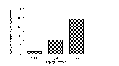
Figure 4.10
Lateral Maneuver Rate - Bank Angle Exceeded 10û
(hazardous straight & level and descent scenarios only)
Subjects initiated a lateral maneuver in nearly 80% of the incidents represented in Figure 4.10 when using a plan view display. This rate dropped to approximately 30% when using the perspective view, and 5% when using the profile view. Each of these differences is statistically significant using a chi-square test (p < 0.01). These results agree with the differing amount of lateral information provided on the displays.
4.5 Lateral maneuvers when in a turn
Figure 4.11 shows a breakdown of the lateral maneuvers used in the three hazardous terrain scenarios in which the aircraft was in a turn when the alert appeared, for the three display formats. The lateral maneuvers were examined for 15 seconds after the pilot activated the sidestick and were classified as one of the following three categories:
1. Turn continued: the subject maintained at least 10û bank angle (in the same direction as at the start of the scenario) for 15 seconds.
2. Turn reversed: the subject exceeded a 10û bank opposite to the original turn direction within 15 seconds.
3. Turn ended: the subject brought the aircraft’s wings level (to less than 10û bank angle) within 15 seconds.
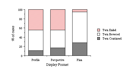
Figure 4.11
Lateral Maneuver Behavior
(hazardous scenarios where aircraft was in a turn when hazard appeared)
When using the plan view display, the subjects chose to maintain a turn or reverse directions in the majority of the cases (95%). Pilots were more likely to end a turn and perform a wings level pull-up when using the profile or perspective display. This difference in maneuver behavior is statistically significant (p < 0.05, chi-square test). Interestingly, the data also show that regardless of the display subjects were reticent to continue a turn, and more often than not reversed the direction of the turn. This result, though not statistically significant, suggests that if the aircraft was in a turn when a hazard appeared, subjects tended to believe that they were better off reversing the turn than continuing the turn. While this logic may have been chosen because of the lateral information conveyed by the plan or perspective displays, the subjects still tended to reverse turns rather than continue them even when using the profile view display where they had little corroborating information to support their turn decision.
4.6 Subjective results
At the conclusion of the data collection runs, the subjects were asked to rate the three display formats in terms of their effectiveness in providing them with an intuitive picture of the terrain hazard. Figure 4.12 shows the mean ratings received for each display format. The plan and perspective formats were generally rated as more effective than the profile view display. The lack of lateral information on the profile view was cited as the principle reason for the low ratings received on that display.
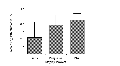
Figure 4.12
Subjective Ratings of Display Formats
The subjects also ranked the three display formats from most to least desirable, as shown in Figure 4.13. Every subject rated the profile view display as the worst of the three formats. The plan view format was raked most desirable by all but one subject.
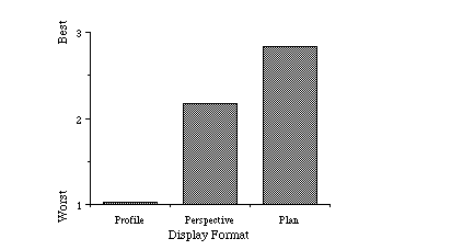
Figure 4.13
Display Format Rankings
5. Summary and Conclusions
A summary of the primary results of this study follows:
1. The perceived severity of terrain hazards was fairly well related with the true level of hazard except for two situations. In one, no display format was found to transmit the true level of hazard posed by descent into flat terrain. The aircraft impacted terrain in this situation 50% of the time when using the plan or perspective display formats. The profile view display appears to have been more effective in eventually transmitting the level of hazard since all subjects were able to avoid the hazard when using this display. In the second situation, the profile and perspective view displays apparently did not provide enough lateral information to allow the subjects to verify that their route of flight would turn before getting near a ridge. The plan view display also appeared to mislead several subjects into feeling that this scenario was more hazardous than it really was.
2. Mean peak load factor appears to be an acceptable benchmark by which to compare the aggressiveness of an escape maneuver. While load factor does not explicitly account for extreme bank or pitch attitudes, it is a measure of the rate of change in the direction of the aircraft’s velocity vector. Data for mean peak load factor generally followed the trends seen in the subjective hazard rating and peak climb rate data.
3. An analysis of mean peak climb rates show that when using the profile view display pilots generally used lower climb rates than when using the other two display formats. In cases where the profile display’s climb rates were significantly lower than the other display formats, the minimum height above ground was never significantly below that of the other displays - in fact in one situation it was significantly higher. All but three of the perspective display scenarios exhibited higher climb rates than when using the plan or profile view displays.
4. Pilots initiated a lateral maneuver 80% of the time when viewing the plan view display, 30% of the time with the perspective view display, and only 5% of the time with the profile view display.
5. When an alert appeared while the aircraft was in a turn, pilots continued or reversed the turn significantly more often when using the plan view display than when using the profile or perspective displays. The data also suggest that pilots were more likely to reverse the direction of a turn than continue it, even when using the profile display which did not provide any supporting lateral information to the subjects.
6. Subjective ratings of the display ranked the plan view display slightly ahead of the perspective view display. The profile view display was disliked since it lacked lateral information. Several subjects suggested that using both the plan view and perspective view displays would be a good combination of display options.
The above results may be extrapolated to the following conclusions about each of the display formats.
5.1 Plan View Display
When using the plan view display, lateral maneuvers were used far more often (83% of the time) than the currently prescribed wings-level pull-up maneuvers. This display also appeared to have the best chances for correctly conveying to the pilot that an alert was a false alarm when lateral separation was important. The plan view display was poor in depicting the true hazard when descending into flat terrain, and 50% of these incidents resulted in the aircraft impacting the ground. However, all but one subject ranked this display as the best of the three, and the plan view was also rated as more effective on average than the other formats.
These results suggest that pilots would like to have lateral as well as vertical separation information on a terrain display. However, the true tradeoffs between turn rate and potential climb rate in a terrain field must be examined before it is likely that lateral terrain avoidance maneuvers would be suggested. In such cases, it may be necessary to provide the flight crew with additional information regarding the aircraft’s ability to turn or climb when avoiding terrain.
5.2 Profile View Display
The profile view display was the least preferred of the three display formats, and was poor in the situation where the aircraft was turning safely in front of terrain. This display, like the other two formats, did not initially convey the true hazard level posed by descent into flat terrain. However, the fact that no subjects impacted terrain with this format suggests that it did eventually convey the hazard to the aircraft due to flat terrain.
When using this display, subjects were equally likely to perform a wings-level pull-up as to reverse the direction of the turn. It appears that when a terrain alert was triggered in a turn the subjects tended to believe that the turn was the source of the alert and thus reversed direction. This strategy, however, could possibly lead to an even more hazardous situation than the one initially causing the alert.
Climb rates when using the profile display were significantly lower than when using the other two formats in 3 of the 12 scenarios, and significantly lower than one of the display formats in 6 of the scenarios. This, when considered in the light that minimum height above ground was not significantly lower in these cases, suggests that the profile view display may be more efficient in aiding pilots to clear terrain with a minimum of vertical speed. However, since the lateral behavior of the escape maneuvers varied greatly across display types, it may not be possible to extrapolate these results this far.
The profile display was ranked last among the three display formats by all subjects, and received the lowest ratings for effectiveness, mirroring the subjects’ dislike for the limited extent of lateral information on this display.
5.3 Perspective View Display
The perspective view display appears to have been a compromise between the large lateral depiction of terrain available on the plan view and the more focused, limited view of terrain on the profile view. Climb rates were higher when using the perspective display than when using another format in all but three scenarios, suggesting that pilots wished to provide larger vertical separation between the aircraft and terrain when using this display. When using the perspective display, lateral maneuvers were initiated more often than when using the profile display, and less often than when using the plan view display. In hazard scenarios where the aircraft was in a turn, pilots tended to use the perspective view as they used the profile view, often reverting to a wings-level pull-up.
The perspective view, like the plan view display, was poor in providing an intuitive picture of the hazard posed by a descent into flat terrain. 50% of these cases ended in the aircraft impacting the flat terrain.
5.4 General comments
Overall, the subjects were in favor of using a plan view display, with several commenting that a combination plan and perspective display system would provide the best combination of the displays. These displays could be added directly to existing electronic displays, without the requirement for an additional display (or reformatting the EHSI) that would be needed with the profile display.
The disadvantages of the plan and perspective display, however, will still need to be addressed before they may be used in aircraft. Their principle drawback lies in their poor effectiveness in conveying the vertical extent of terrain to the pilot. The plan view display requires differently colored contours to do this task, which become ineffective when flying over flat terrain, and may cause additional problems if weather radar returns are superimposed over terrain contours. The perspective view display, since it depicts the terrain as it would appear out the window, ‘flattens’ out the terrain - length scales of the vertical extent of terrain are generally much smaller than the horizontal distances. Exaggerating the vertical scale of terrain on the perspective display eliminates the 1:1 angular correspondence between the terrain and the pitch ladder on the EADI, making a velocity vector ambiguous. The ambiguity between distance and altitude of terrain on the perspective display may have caused pilots to be unsure of what their terrain separation was, leading them to use higher climb rates than they used with the other display formats.
The implementation of any of these display formats will require the thorough investigation of the proper escape maneuvers that may be used. Unless strict training forces crews to act otherwise, it appears that lateral maneuvering will be a principal component of escape maneuvers regardless of display format. In order to provide pilots with the information needed to decide whether to continue a turn, reverse it, or go wings-level, it may be necessary to provide additional information on the displays, such as arcs indicating possible lateral trajectories - both in and against the current direction of turn, or arcs showing the aircraft’s projected climb capability. The addition of these elements, however, would add additional clutter to an already dense display showing navigation and terrain information. If a profile display is the only source for terrain hazard information, it may be possible to mandate wings-level pull-up maneuvers, but it appears that flight crews will at times have an instinctual tendency to reverse the direction of a turn.
The final choice regarding which display or displays should be implemented in an aircraft cannot yet be answered. This study has highlighted some of the areas which will require greater investigation, such as descent into flat terrain and issues regarding lateral maneuvering. Additional examination of these issues, as well as an investigation of possibilities for combined plan-perspective or plan-profile displays needs to be performed.
Acknowledgments
This work was supported by funding from The Boeing Commercial Aircraft Company.
The authors thank Maureen Hunter and George Boucek from Boeing for their valuable input throughout this study. We also are very appreciative of the subject pilots who volunteered their time to participate in the study.
We appreciate the input from Bob Giuda of United Airlines, as well as the aid given us by Don Sellars and Jim Savard from Jeppesen Sanderson, Inc.
Thanks also to the ASL simulator team, especially to Dave Rahn who aided in setting up the data acquisition hardware for the sidestick controller.
Much appreciation is also extended to Bob Haimes for aiding us in obtaining color printouts of the simulator displays.