Bicycle Directions to Jeff & Nancy's House from Boston
Notes:
Please note that we have two cats. If you are allergic to cats, don't
forget to bring your antihistimines.
The maps on this page were produced by MapQuest and edited with xpaint.
Summary: Rte. 99 past Rte. 16 and into Everett. Right on Reed Ave. Left
on Elm St., which becomes Park Ave. in Revere. Dogleg right onto Broadway,
then left onto Winthrop Ave. Left on Hillside Ave. which becomes Centennial
Ave. Left on Ocean Ave., and first right onto Revere Beach Blvd. Cross
General Edwards drawbridge into Lynn. Lynnway/Carroll Parkway to rotary.
Cross the causeway via parking lot, then rejoin Nahant Rd. First left onto
Little Nahant Rd. 2nd house on the left.
Total distance is approximately 14 miles from Cambridge.
- From Cambridge, cross the Prison Point (Gilmore) Bridge and continue
straight on Austin St. for about 0.2 mile to the fork.
- Take the left fork and then turn left at the light onto
Main St.
- Follow Main St. for 0.7 mile to Medford St. You'll see the Schrafft's
plant on the corner.
- Turn left on Medford St. and cross the tracks, which
will bring you to the Sullivan Square rotary.
- Take the first exit out of the rotary, onto Rte. 99 North. (Left
diagram below.) There will be a lot of traffic on Rte. 99, but it's
wide enough that you should be able to stay out of the way.
- In 1.5 miles, you'll come to the rotary above Rte. 16. Watch traffic,
and stay on 99 North, which is the second exit from the rotary. (Right
diagram below.)
- 0.5 mile after the rotary, turn right onto
Summer St., at the Li'l Peach convenient store.
- Follow Summer St., which will become High St. after a
few blocks, for 0.4 mile until it ends at Ferry St.
(Left diagram below.)
- Turn left onto Ferry St.. (Right
diagram below.)
- After 0.3 mile, turn right at the first traffic light
onto Elm St.. There will be a fire station on your
right.
- After about 0.8 mile, you'll cross into Revere and you'll cross over
Rte. 1. Elm St. becomes Park Ave. in Revere.
- About 1.1 mile after you cross over Rte. 1, Park Ave. ends at Broadway.
Dogleg right onto Broadway, then left
onto Winthrop Ave. (It's marked "No Left
Turn," but you should be able to get away with it anyway.)
- Immediately after the dogleg, take the right fork to
stay on Winthrop Ave.
- After 0.5 mile, you'll cross Rte. 16 at a 5-way intersection. Go
straight, staying on Winthrop Ave., which is now Rte. 145. Note that
this section of Winthrop Ave. is 3 lanes in each direction, and has no
shoulder.
- Less than 0.1 mile after crossing Rte. 16, you'll cross over the
commuter rail and then under Rte. 1A. 0.4 mile after you cross under
1A, turn left at the first traffic light onto North Shore
Road, following the sign for the Garfield Magnet School.
You'll see a Best gas station on the left at the intersection. If you
pass Suffolk Downs racetrack, you went too far.
- Go 0.5 mile on North Shore Road. After you pass Atlas Auto Body
(which will be on your left), turn right at the first
traffic light onto Shirley Ave..
- Go one block and take your first left, staying on
Shirley Ave. After you make the turn, you'll cross over the blue line,
and you'll pass Revere Beach T station on your left.
- Cross Ocean Ave. (at the light) and turn left at the
end of Shirley Ave. onto Revere Beach Blvd..
- Follow Revere Beach Blvd. along the ocean for 2.6 miles until it ends.
You'll have a nice view of Nahant on your right. When Revere Beach
Blvd. ends, follow the signs that say "Rte. 1A North,
Lynn/Swampscott", which will funnel you up an on-ramp and onto the
General Edwards Bridge. The bridge doesn't have much of a shoulder, so
you may be better off on the sidewalk.
- Once you've crossed the drawbridge, you're on the Lynnway in Lynn.
Unfortunately, there is no shoulder on the Lynnway, so you are probably
better off riding on the sidewalk here as well. Fortunately, there
isn't much pedestrian traffic along the Lynnway. Follow the
Lynnway/Carroll Parkway for 2.0 miles, until it ends at a rotary.
(Rte. 1A will turn off 0.5 mile before the end of the parkway.)
- At the rotary, take the first exit onto Nahant Road, which will put you
on the Causeway to Nahant.
- Take your first left after exiting the rotary, into the MDC parking
lot. (You can't bicycle down the causeway, but you can bicycle down the
parking lot, which runs the entire length of the causeway.)
- At the end of the parking lot, get back onto Nahant Rd.
- Go about 0.2 miles down Nahant Rd. and take your first
left onto Little Nahant Rd. This turn is hard to see
until you're right there, but there's a stone wall on your left just
before the turn. If you get to a boarded up Coast Guard station on your
left, you went too far.
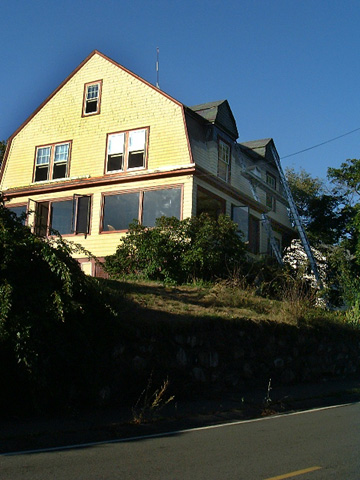
- Our house is 8 Little Nahant Road. It's the second
house on the left, at the first curve in the road. The house is a
yellow gambrel-roofed Dutch colonial, with red trim. The house number
is on the lamp post.
Here is a picture of the house, as you approach it on Little Nahant Road:
Telephone
Our telephone number is (781) 592-5802.
Other directions to Jeff & Nancy's house / jcb's homepage / send email
Last modified: Mon Sep 9 02:17:51 2002
by jcb@mit.edu