Directions to Jeff & Nancy's House from Rte. 128 or From the North
These are the detailed directions. If this is too much detail, try the short directions instead.
Notes:
Please note that we have two cats. If you are allergic to cats, don't
forget to bring your antihistimines.
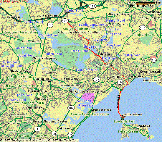
The maps on this page were produced by MapQuest and edited with xpaint.
Summary: Exit 44B (or 44) to Rte. 129 East until the 129/129A split. Then
go straight until you hit water.
Estimated travel time from Rte. 128 is 10-15 minutes.
Details:
- Use your favorite maps, road signs, etc. to find your way to
I-95 and/or Rte. 128. If you're travelling at or near
rush hour, check the Rte. 128
and/or I-95
traffic reports.
- If you're coming from South, West or Northwest of Boston, get on
I-95/Rte. 128 Northbound. If you're coming from Northeast of Boston
(where I-95 and Rte. 128 are separate roads), get on I-95 or Rte. 128
Southbound.
- If you're on 128/I-95 North, get off at Exit
44B and follow signs to Route 129 East. (Do
not get off at Exit 40 or Exit 44A even though these exits also go to
route 129.) 129 bears right at the exit.
If you're on 128/I-95 South, get off at Exit
44 and follow signs to Route 1 South. (Do not
get off at any of the earlier Route 1 exits.) When you get onto Rte. 1,
you'll get your own lane. Stay in this lane and follow it when it exits
(which will be the second exit), onto Route 129 East.
Watch the intersection at the end of the ramp--the first possible left
bypasses the intersection and puts you back on 1 north toward route
128/I-95. You want the second possible left, through the intersection
with the traffic light, onto 129 East.
- Very shortly, you will come to a rotary. (That's what New Englanders
call traffic circles). (This is where the directions from 128/95 North
and from 128/95 South merge.) Get out of the rotary onto 129
East (which is also called Lynnfield Street).
Note your mileage (or zero your trip odometer) as you leave the rotary.
Once you're out of the rotary, forget about route numbers and street
names, and just go straight at every intersection until you get to the
ocean (about 5 miles). (At one point, you'll go straight and 129 will
turn off.) It may not be entirely clear what "straight"
means, but if you follow your instincts, you will end up in the right
place. Note also that the road will get narrower and narrower. Just
when the road is so narrow that you think you might be in someone's
driveway, the road will curve sharply to the right and end at the ocean.
Here are some landmarks:
Miles
From
Prev. |
Total
Miles |
Description of Intersection or Landmark |
| 0.0 mi. |
0.0 mi. |
Goodwin's Circle. Rotary where Rte. 128/I-95, Rte. 1 and
Rte. 129 meet. You're now on Lynnfield St.
|
| 2.6 mi. |
2.6 mi. |
Wyoma Square. A fairly big intersection. The sign saying
"Wyoma Square" is after you leave the square. You're
now on Broadway. |
| 0.5 mi. |
3.1 mi. |
129/129A fork. There's an Exxon station in the middle of the
fork. You want to go straight (which is the left fork) onto
129A. You're now on Chestnut St. (Note that
129 was relocated through Lynn a couple of years ago. 129A is
still labeled as 129 on most maps.) |
| 0.4 mi. |
3.5 mi. |
129A turns off, joining 107. You continue straight on Chestnut
St. |
| 1.0 mi. |
4.5 mi. |
You cross a bridge over the railroad tracks. Follow Chestnut
St. around to the right after the bridge. (You can't go
straight here, so the closest thing to straight is to stay on
Chestnut.) |
| 0.2 mi. |
4.7 mi. |
You go straight across Rte. 1A at a traffic light. You're now
on Atlantic St. |
| 0.2 mi. |
4.9 mi. |
You come to a stop sign. After the stop sign, the road is
noticeably narrower, and looks like it might be a private road
or driveway. Don't worry. It isn't. You're now on
Atlantic Terrace. |
| 0.1 mi. |
5.0 mi. |
Atlantic Terr. curves sharply to the right and ends at a stop
sign. You see the Atlantic Ocean in front of you.
|
- At the end of Atlantic Terrace, turn right (the only
direction you can legally turn) onto Lynn Shore Drive.
- After 0.5 mile, you'll come to a rotary. Go straight
(about 2/3 of the way around), getting onto the causeway (Nahant
Rd.) towards Nahant. There's a white "Entering
Nahant" sign on the right just before you leave the rotary.
- Follow the directions below labeled "End
Game."
Summary: Washington St. out of Peabody Square. Bear left on Lynn
St. (which becomes Broadway in Lynn). In Wyoma Square, bear left, staying on
Broadway. Then follow the directions from 128 above, starting from Wyoma
Square.
Details:
- Take Washington St. out of Peabody Square.
- Bear left at the fork (toward Lynn) onto Lynn
St.
- Lynn St. will become Broadway in Lynn.
- When you get to Wyoma Square (a major intersection), Broadway makes a
left turn. Once you've made this left turn, you're in the middle of the
directions from Rte. 128 above. Find Wyoma Square on
those directions, and continue from there.
Summary: Rte. 1A South through Salem and Swampscott into Lynn. Left at
the first traffic light in Lynn. Right at the ocean. Straight to the rotary,
then End Game.
- Get on Rte. 1A South and follow it through Salem and
Swampscott.
- Zero your trip odometer or note your mileage when you reach the
Salem/Swampscott line, which is in Vinin Square, a half-mile long strip
of shopping centers.
- 1.6 mile after the Salem/Swampscott line, watch for C & L Bottled
Liquors on your right, in the middle of an S curve in the road. After
this curve, you will go through a traffic light, and then you will see a
white sign on the left side of the road that says "Entering
Lynn." At the traffic light immediately after the "Entering
Lynn" sign (which is 0.1 mile after the liquor store), turn
left onto Eastern Ave./Rte. 129 East
- 129 turns off (but you don't) after one block. Stay on Eastern Ave. for
a second short block, until it ends at the Ocean.
- When you get to the ocean, turn right onto
Lynn Shore Drive.
- After 1.0 mile, you'll come to a rotary. Go straight
(about 2/3 of the way around), getting onto the causeway (Nahant
Rd.) to Nahant.
- Follow the directions below labeled "End
Game."
Summary: End of causeway. Second left. Second house on the left.
Details:
- Travel the length of the causeway (about 1.4 miles). If it has recently
rained heavily and it is near the time of high tide,
stay in the left lane to avoid the large puddles.
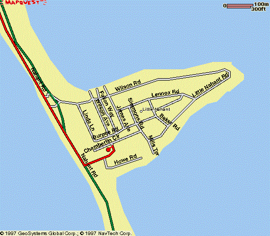
- 0.2 mile after the causeway ends, take your second left
onto Little Nahant Road. This turn is hard to see
until you're right there, but there's a stone wall on your left just
before the turn. If you get to a boarded up Coast Guard station on your
left, you went too far.
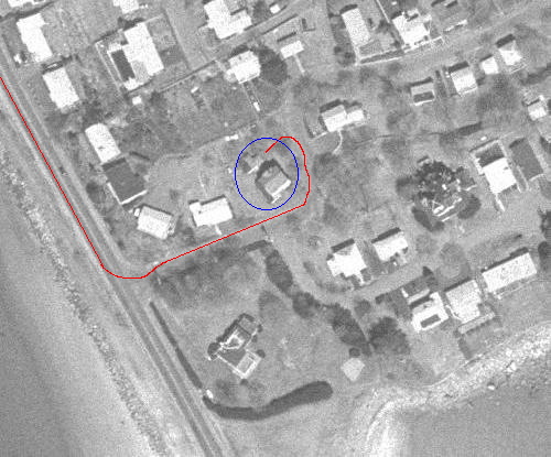
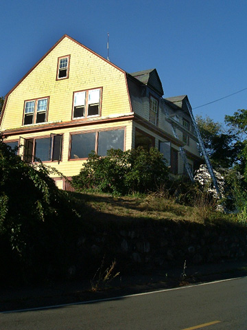
- Our house is 8 Little Nahant Road. It's the second
house on the left, at the first curve in the road. The house is a
yellow gambrel-roofed Dutch colonial, with red trim. The house number
is on the lamp post.
The best places to park are in the driveway, in the spaces behind the
garage (which are accessible from Chamberlin Circle), or on etiher side
of Chamberlin Circle. If Chamberlin Circle is parked up, ask us for
other options. (Sometimes some of our neighbors let us use parts of
their driveways.)
Here is a picture of the house, as you approach it on Little Nahant Road:
Telephone
Our telephone number is (781) 592-5802.
jcb's homepage / send
email
Last modified: Sun Apr 17 09:25:05 2005
by jcb@mit.edu